I use postgis extensively in my geo-local development. If you’re working on a project that involves geo data and you haven’t seriously looked into postgis, you’re doing yourself a disfavour.
Postgres is really quite epic.
- Postgis
- R for Postgres
- Python for Postgres
- A nice stable API for creating C++ extensions
We used the C++ API to make a xapian plugin for zoomin, back in the day before tsearch2 became integrated into Postgresql.
Twitterplaces
Sam asked that I add polygons onto my twitterplaces maps, so that he could see where the boundaries of a neighbourhood are.
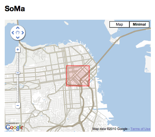
South of Mission on Twitterplaces
The twitter places API gives you the bounding boxes of a place, so I already had the information, it was just a case of how to store the bounding boxes. I decided to do it properly and use spatial_adapter and a :polygon column in my places table.
This meant I could use a method like so:
def bounding_box=(params)
  points = []

  params['coordinates'].first.each do |c|
    points.push GeoRuby::SimpleFeatures::Point.from_x_y(c.first, c.last)
  end

  self.latitude = points.collect(&:y).sum / points.length
  self.longitude = points.collect(&:x).sum / points.length

  c = params['coordinates'].first.first
  points.push GeoRuby::SimpleFeatures::Point.from_x_y(c.first, c.last)
  self.geom = GeoRuby::SimpleFeatures::Polygon::from_points([points])
end
To convert twitters json representation of a place into a WKRT geometry object in my database. This is cool, because then I can use some coffeescript like this to draw the polygon onto my maps.
if $place.geom.rings
  points = []
  bounds = new google.maps.LatLngBounds

  for point in $place.geom.rings[0].points
    coord = new google.maps.LatLng(point.y, point.x)
    bounds.extend coord
    points.push coord

  if bounds.toSpan().lat() == 0.0 or bounds.toSpan().lng() == 0.0
    marker = new google.maps.Marker {
      map : map
      position : bounds.getCenter()
    }
  else
    poly = new google.maps.Polygon {
      paths : [points]
      map : map
      strokeColor : '#ff0000'
      strokeOpacity: 0.5
      fillOpacity : 0.1
      fillColor : '#ff0000'
    }
That code also checks whether the polygon is degenerate (of zero size), and then plots a marker instead. Twitter always sends polygons, even if the polygon has zero area. Anyway. So this was all nice and took 15 minutes to code up. But it also let me do something super awesome:
def find_child_pois
  Place.find(:all, :conditions => ['kind = ? AND st_contains(?, geom)', 'poi', geom])
end
I now have a method to find all places contained inside a place. So for example, South of Mission in San Francisco, has Adobe Systems inside of it. You can also find out which places contain this one - for example:
>> Place.find_by_path('sfo/soma').find_parents.collect(&:name)
=> ["San Francisco", "SoMa", "California"]
I was pretty excited when all this came together so well. When I’ve got more time, I’d like to fix up the crawler that feeds twitterplaces, since at the moment it just dumps the database and recreates it every hour from a sampling of the twitter firehose.
Ah - for more good hours in the day.

 atom feed
 github
 twitter